Why PurVIEW:
1. Seamlessly Integrated
2. No CAD, no translation, no retrograde
3. Geodatabase-direct editing/mapping
|
| PurVIEW Explorer |
 |
 |
|

PurVIEW Explorer
Inspect imaging delivery. Quality Assurance of geodatabase contents.
|
Field verification of a geodatabase is impractical. Orthophoto is viable only if the data model is still flat-earth 2D… and unusable for new 3D mapping QA.
PurVIEW pre-empts such challenges.
Supports:
- Aerial frame-camera image models
- RPC imbedded space-borne imagery
- ADS-40, ASTER, SPOT imagery
|
|
 |
 |
|
|
 |
 |
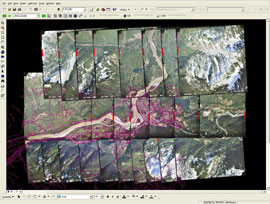
Displays thumb-nail image composite for entire project, over a map base, with
zoom-in stereo viewing, on demand.
Standard media for digital imaging delivery is...digital. First-viewing on a computer monitor is not only logical, but economical.
|
|
|