Why PurVIEW:
1. Seamlessly Integrated
2. No CAD, no translation, no retrograde
3. Geodatabase-direct editing/mapping
|
|
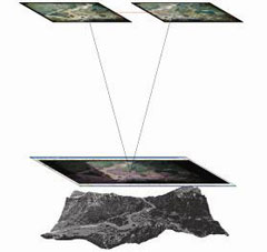
Stereo Vision —caused by the slightly different viewing perspective of the left and right eye—is intrinsic to the sense of sight. This view parallax that enables distance estimation is rigorously and conveniently simulated using eyewear with synchronized LCD shutters.
|
Virtual-Z ™ enables default 3D feature digitizing by extracting Z values for arbitrary cursor positions from Arc-TIN Datasets or DEM. The monitor cursor is observable tracking automatically the apparent terrain undulations.
Features naturally residing on terrain surfaces will be digitized conformal to the terrain model surface.
|
|
 |
 |
|
| |
 |
 |
The imaginary line connecting the view perspective centers is the base-line for aerial triangulating object positions.
|
Image geo-referencing are either directly recorded in an Inertial Measurement Unit (IMU) during imaging or recovered through photogrammetric Aerial Triangulation post-processing, and are simply:
- Sensor position at the instant of imaging, notated as Xo Yo Zo.
- Sensor aim imparted by platform yaw, pitch & roll, notated as κ (kappa), φ (phi) and ω (omega).
|
DEM is a staple ingredient in orthophoto processing.
Vertical accuracy in photogrammetric DEM is considered First-Order if within 1/3,000 of flying height, and Second-Order if within 1/2,400.
DEM is also acquired direct via LiDAR or RADAR systems, both well within First-Order standards. Aerial platforms typically used limit vertical resolution to ~10cm for LiDAR and ~1m for IfSAR RADAR.
RADAR is also used in space-borne platforms. For example, the NASA Shuttle RADAR Topography Mission produces vertical DEM accuracy of ~15m.
|
| |
|